Skip Navigation Bar
NASAGoddard Space Flight Center+ Aura @ NASA
Aura banner
OverviewAura ScienceProjectOutreach
Aura Mission Overview + Data & Images + Multimedia + Publications + Presentations + Science Q & A


Aura Spacecraft Illustration

+ Home
view collection
2009
2009 2008 2007 2006 2005
2009 hirdlsomimlstes

Aura Science : Data and Images : 2005

Aura Science Result Image
NASA Satellite Eyes Atmosphere to Improve Pollution and Climate Forecasting
Thanks to the latest sophisticated, satellite-based instruments, local and regional air pollution and their sources can now be observed closely from space.
+ More
Aura Science Result Image
Eruption of Anatahan
This image of the volcanic eruptions from Anatahan (Mariana Islands) shows sulfur dioxide concentrations in the atmosphere on April 7, 2005, over 30 hours after the eruption.
+ More
Aura Science Result Image
OMI Measurement of Nitrogen Dioxide
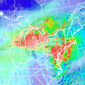
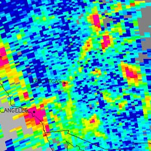
This image from Aura's OMI instrument shows the total column amount of nitrogen dioxide, a precursor to the formation of tropospheric ozone.
+ More
Aura Science Result Image
Destruction of Arctic Ozone this Winter
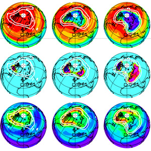
An unprecedended suite of simultaneous measurements by MLS allows more accurate quantification of ozone destruction in the 2004-2005 Arctic winter.
+ More
Aura Science Result Image
MLS detects SO2 and HCI injected into the stratosphere by the 27 January 2005 New Guinea Manam volcano.
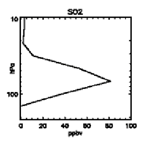
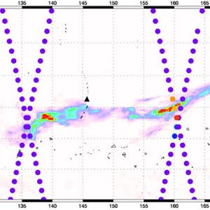
These images show MLS detection of enhanced SO2 and HCI in the lower stratosphere over New Guinea on January 28, following eruption of Manam volcano on January 27.
+ More
Aura Science Result Image
Sulfur Dioxide Plume From Manam Volcano
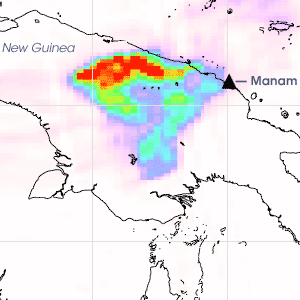
When the Manam volcano erupted explosively in the middle of the night on January 27, 2005, it sent a cloud of ash and sulfur dioxide over New Guinea.
+ More
NASA+ USA.Gov
+ Privacy Policy and Important Notices

Page Curator :
NASA Official: