We analyze new Tropospheric Emission Spectrometer (TES) PAN observations over North America from July 2006 to July 2009. Using aircraft observations from the Colorado Front Range, we demonstrate that TES can be sensitive to elevated PAN in the boundary layer ( ∼ 750 hPa) even in the presence of clouds. In situ observations have shown that wildfire emissions can rapidly produce PAN, and PAN decomposition is an important component of ozone production in smoke plumes. We identify smoke-impacted TES PAN retrievals by co-location with NOAA Hazard Mapping System (HMS) smoke plumes. Depending on the year, 15–32% of cases where elevated PAN is identified in TES observations (retrievals with degrees of freedom (DOF)>0.6) overlap smoke plumes during July. Of all the retrievals attempted in the July 2006 to July 2009 study period, 18 % is associated with smoke.
A case study of smoke transport in July 2007 illustrates that PAN enhancements associated with HMS smoke plumes can be connected to fire complexes, providing evidence that TES is sufficiently sensitive to measure elevated PAN several days downwind of major fires. Using a subset of retrievals with TES 510 hPa carbon monoxide (CO) > 150 ppbv, and multiple estimates of background PAN, we calculate enhancement ratios for tropospheric average PAN relative to CO in smoke-impacted retrievals. Most of the TES-based enhancement ratios fall within the range calculated from in situ measurements.

Average tropospheric PAN in retrievals (DOF > 0.6) during July 2006–July 2009 in a 2◦ × 2◦ grid. The white areas designate locations with less than five measurements during this period. The blue lines surround the regions included in the calculations in the figure on right: 125–70◦ W, 30–50◦ N and 130–65◦ W, 50–70◦ N.
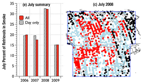
The map shows PAN TES retrievals with DOF > 0.6 co-located with NOAA Hazard Mapping System smoke polygons (red), and PAN TES retrievals with DOF > 0.6 not co-located with NOAA Hazard Mapping System smoke polygons (grey). The black dots indicate PAN TES retrievals with DOF > 0.6 during times with no NOAA HMS data. The histogram indicates the percent of TES PAN retrievals overlapping HMS smoke plume polygons for July 2006–2009. Red bars indicate the percentage of all retrievals overlapping smoke plumes, and the striped bars indicate the percentage of daytime retrievals overlapping smoke plumes. Pairing was done using the matching UTC day.
Scientific significance, societal relevance, and relationships to future missions:
PAN is considered to be the most important reservoir for NOx in the troposphere, and it plays a critical role in the re-distribution of NOx to remote regions. The work presented here highlights the importance of fires as a source of PAN over North America in summer. It also shows that TES measurements of PAN can be used to complement limited in situ measurements of PAN. The apparent significant contribution of fires to elevated PAN plumes over North America underscores the importance of investigating PAN production in smoke to ultimately determine the best way to incorporate the rapid chemistry that produces PAN into chemical transport models that are used to predict background O3 and exceptional O3 events, both of which are important to air quality stakeholders.
Data Sources:
The TES PAN retrievals shown here were processed using a prototype algorithm for the area and time periods of interest. The v7 PAN algorithm was built from this prototype. Specific details of the TES PAN retrieval algorithm are provided in Payne et al. (2014). TES PAN retrievals are being processed routinely for the whole TES dataset and will be publicly available in the TES v7 Level 2 product. TES PAN retrievals were segregated by whether or not the TES footprint coincides with a smoke plume identified by the NOAA Hazard Mapping System (HMS). NOAA HMS is an interactive satellite image and graphics system developed by the National Environmental Satellite, Data, and Information Service (NESDIS). Using satellite imagery, trained analysts identify the geographic extent of smoke plumes in the atmospheric column over North America.
References: Fischer, E. V., Zhu, L., Payne, V. H., Worden, J. R., Jiang, Z., Kulawik, S. S., Brey, S., Hecobian, A., Gombos, D., Cady-Pereira, K., and Flocke, F.: Using TES retrievals to investigate PAN in North American biomass burning plumes, Atmos. Chem. Phys., 18, 5639-5653, https://doi.org/10.5194/acp-18-5639-2018, 2018.
8.2018

