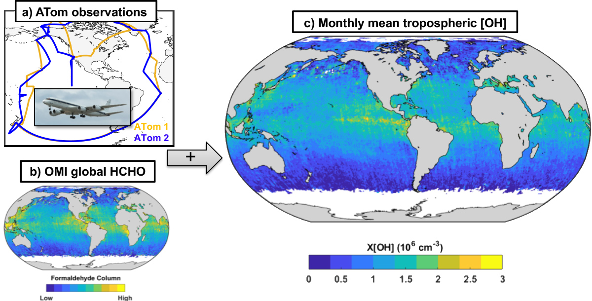
Technical Description of Figures:
a): Flight tracks of the NASA DC-8 (inset) for ATom 1 (August 2016, orange) and ATom 2 (February 2017, blue). Each missions consists of ~11 flights traversing the remote atmosphere with constant vertical profiling from near the surface to 10 – 12 km altitude. The scientific payload includes extensive in situ observations of trace gas and aerosol properties, including HCHO (measured by the GSFC in situ airborne formaldehyde (ISAF) instrument) and OH concentrations. ATom observations allow us to both quantify the HCHO – OH relationship and validate OMI HCHO retrievals.
b): Total column abundance of formaldehyde from August 2016, derived from the Smithsonian Astrophysical Observatory Ozone Monitoring Instrument retrieval (OMI-SAOv003). Columns are averaged over the whole month on a 0.5° x 0.5° grid. The color scale ranges from 0 to 1×10¹⁶ molecules cm-2. Data over land are masked to better highlight the variability of HCHO in remote regions, which is largely driven by OH.
c): August 2016 column-average tropospheric OH concentrations (X[OH]) derived from a combination of ATom insights, OMI retrievals, and additional parameters from GSFC’s GMI model. Median uncertainty in individual grid cells is 0.35×10⁶ molecules cm-3. This is the first ever satellite-derived estimate of the near-global distribution of OH. Note, it is currently only possible to apply this technique in remote regions (over water).
Data Sources:
ATom observations are publicly available at https://doi.org/10.3334/ORNLDAAC/1581. The specific datasets derived here, including the ATom OH merge, ATom integrated columns, gridded OMI HCHO columns, and X[OH], are available at https://doi.org/10.3334/ORNLDAAC/1669.
References: Wolfe, G. M. (614/JCET), Nicely, J. M. (614/ESSIC), St Clair, J. M. (614/JCET), Hanisco, T. F. (614), Liao, J. (614/USRA), Oman, L. D. (614), Brune, W. B., Miller, D., Thames, A., González Abad, G., Ryerson, T. B., Thompson, C. R., Peischl, J., McKain, K., Sweeney, C., Wennberg, P. O., Kim, M., Crounse, J. D., Hall, S. R., Ullmann, K., Diskin, G., Bui, P., Chang, C. and Dean-Day, J., “Mapping hydroxyl variability throughout the global remote troposphere via synthesis of airborne and satellite formaldehyde observations,” Proceedings of the National Academy of Sciences of the United States of America, 116(23), 11171-11180, doi:10.1073/pnas.1821661116.
6.2019

