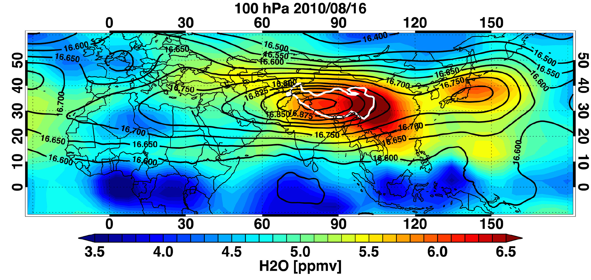
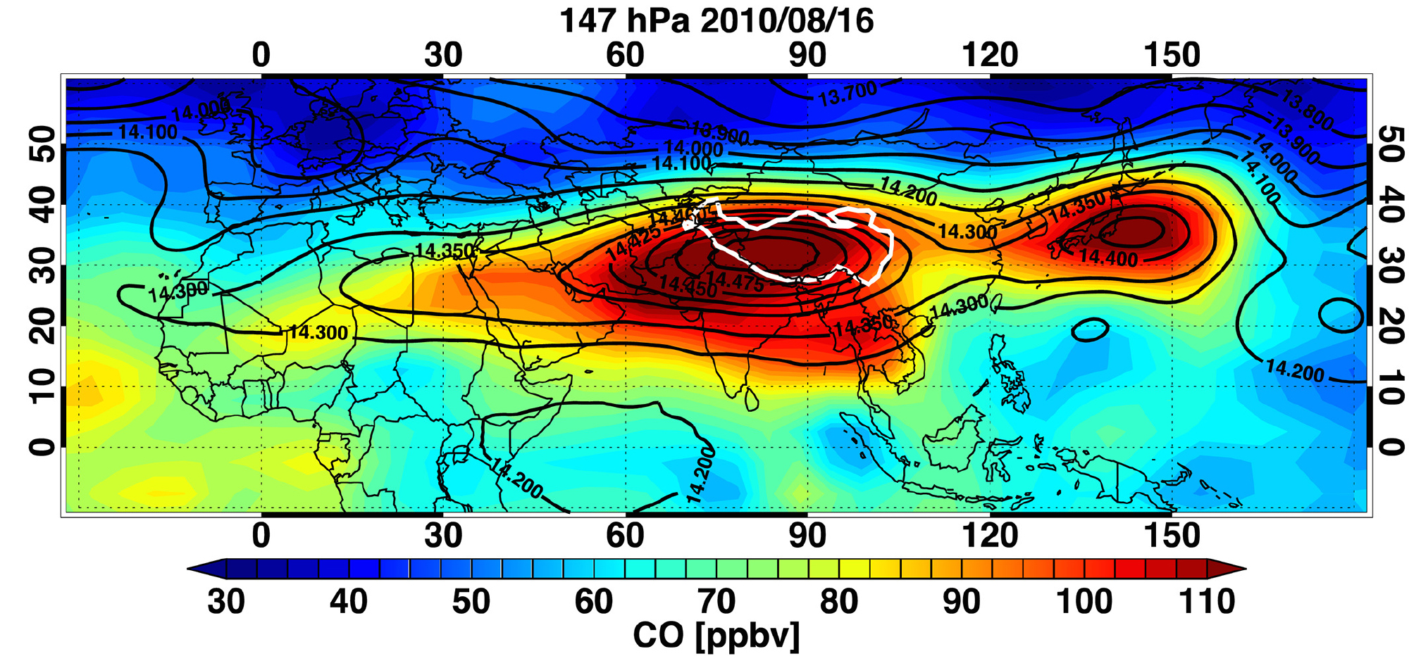
Aura Microwave Limb Sounder (MLS) measurements of water vapor (H2O, top, at 100 hPa) and carbon monoxide (CO, bottom, at 147 hPa) show the chemical signature of air trapped inside the main ASM anticyclone as well as a smaller anticyclone over the Western Pacific (WP) Ocean on a representative day (16 August 2010) during the peak of the ASM season. Contours of geopotential height from meteorological reanalyses (black overlays) delineate the approximate boundaries of the anticyclones; the Tibetan Plateau is outlined in white.
Intense deep convection associated with the Asian summer monsoon (ASM) lofts surface pollutants to the upper troposphere / lower stratosphere (UTLS, ~10–15 km altitude), where air masses remain largely confined within the closed circulation of the ASM anticyclone for days to weeks. Subseasonal scale east-west oscillations cause secondary anticyclones to break off from the main circulation system, resulting in the transport of monsoon-lofted Asian boundary layer air over the Western Pacific (WP) Ocean in a process known as eastward eddy shedding.
This work uses dynamical variables (geopotential height (GPH), winds, etc.) from meteorological reanalyses and trace gas measurements from the Aura Microwave Limb Sounder (MLS), along with a trajectory model, to quantify eastward eddy shedding and associated chemical transport. Enhanced water vapor (H2O) and carbon monoxide (CO) mixing ratios colocated with elevated GPH, which marks the anticyclone, are a clear chemical signature of the ASM. Similar enhancements over the WP are shown to arise not from local sources but from quasi-horizontal transport via eastward eddy shedding. A closed circulation is found to occur over the WP for ~40% of the ASM season. The WP is thus a key pathway for emissions to enter the UT. More than half of the UT air masses in the WP ascend into the LS within a week.
Scientific significance, societal relevance, and relationships to future missions:
The Asian summer monsoon system includes a large‐scale anticyclonic circulation in the upper troposphere / lower stratosphere (UTLS) that spans much of Asia and northern Africa. Satellite observations have revealed high concentrations of surface pollutants and aerosols trapped within this anticyclone. These chemical signatures highlight the role of monsoon convection in transporting regional emissions into the UTLS, affecting the global atmosphere. This work demonstrates that eastward eddy shedding associated with the subseasonal scale dynamics of the anticyclone transports monsoon‐lofted Asian boundary layer air to the Western Pacific (WP) Ocean over timescales of 10 to 20 days. The results of this transport analysis demonstrate that the region of the WP affords excellent opportunities for investigating the impact of the ASM on global UTLS chemical and aerosol composition and provide essential information for the design and implementation of airborne field campaigns targeting ASM air masses over the WP.
No concrete plans for future height-resolved satellite measurements of UTLS CO (by NASA or other agencies) currently exist. The Belgian Altius mission will measure stratospheric water vapor, but only in a sparse "solar occultation" geometry. The Swedish SIW mission will make daily near global stratospheric water vapor measurements, but they will not extend into the upper troposphere.
Technical description of figure:
Figure 4 of above reference. An example of chemical signatures associated with the Western Pacific (WP) anticyclone, which is indicated by the closed contour in the geopotential height (GPH) field (solid black overlays, in km). The color shading shows the distribution of (top) H2O at 100 hPa and (bottom) CO at 147 hPa, both interpolated from a single day of Aura MLS data for 16 August 2010. GPH fields are taken from ECMWF ERA-Interim. The outline of the Tibetan Plateau is marked in white.
Data Sources: MLS carbon monoxide and water vapor data are available from the NASA Goddard Earth Sciences Data and Information Services Center (GES DISC). The DOI for ozone is https://doi.org/10.5067/Aura/MLS/DATA2017 and https://doi.org/10.5067/Aura/MLS/DATA2005 for carbon monoxide. ERA-Interim output was accessed from the NCAR Research Data Archive (RDA); the DOI is https://doi.org/10.5065/D6CR5RD9.
References: Shawn B. Honomichl and Laura L. Pan, Transport From the Asian Summer Monsoon Anticyclone Over the Western Pacific, J. Geophys. Res. Atmos., 125, e2019JD032094, doi:10.1029/2019JD032094, 2020.
11.2020

