Taking advantage of the stable, high-quality data from the NASA Aura Ozone Monitoring Instrument (OMI) and fine resolution data from the ESA Sentinel 5 Precursor TROPOspheric Monitoring Instrument (TROPOMI), this work develops a new fine resolution health-relevant ambient ground-level nitrogen dioxide (NO2) concentration product that can provide a more complete and reliable picture of both long- and short-term changes in NO2 exposure, including associated with the efforts to control the spread of COVID-19.
Technical Description of Figure(s):
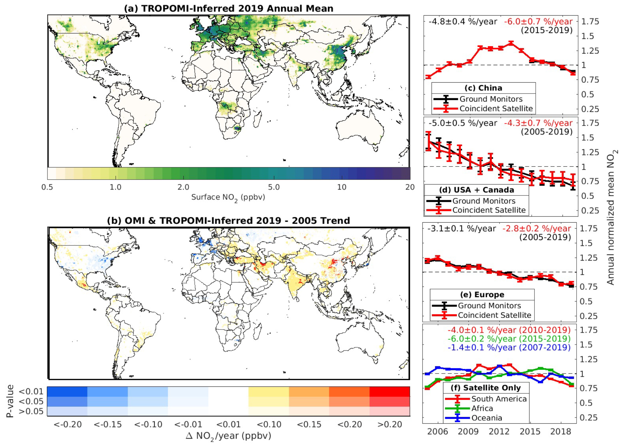
(a) TROPOMI-derived 2019 annual mean ground-level NO2 concentrations at ~1x1 km2 resolution. (b) Trend in OMI and TROPOMI-derived annual mean ground-level concentrations from 2005-2019. Color intensity represents the statistical significance of the trend. (c-e) Population-weighted mean NO2 from ground monitors and from satellite-derived NO2 sampled at ground monitor locations in North America, Europe, and China, normalized by the mean concentration during the period where ground monitor data is available. Trends during the period where ground monitor data are available are inset. Only monitors with data available over the entire time period are included. Error bars represent uncertainties. (f) Population-weighted mean satellite-inferred ground-level NO2 concentrations in South America, Africa/Middle East, and Oceania. Trends during the given time periods are inset. Time periods were chosen to reflect the most recent years where a consistent trend is observed.
Scientific significance, societal relevance, and relationships to future missions:
Nitrogen dioxide (NO2) is an important contributor to air pollution and can adversely affect human health. Combining NO2 column observations from OMI and TROPOMI satellite instruments, this work develops the first spatially resolved, global ground-level NO2 concentrations at sufficiently fine resolution (~1 km) to allow assessment of individual cities. The long-term data record provides an opportunity to examine trends in ground-level NO2 over the last 15 years to provide context for the most recent changes during COVID-19 restrictions. The ability to infer global ground-level NO2 concentrations with sufficient resolution to assess individual cities and even within-city gradients is a breakthrough in satellite remote sensing instrumentation and algorithms. These data offer information to improve NO2 exposure estimates, to examine exposure trends, and subsequently estimate changes in health burden. These developments provide an unprecedented opportunity for advances in air quality health assessment in relation to NO2 and its combustion-related air pollutant mixture. Furthermore, these data serve as foundation for future instruments, including geostationary instruments, such as TEMPO.
Data Availability:
The OMI and TROPOMI NO2 data and relevant documentation are publicly available from the NASA Goddard Earth Sciences Data and Information Services Center (GES DISC) website.
References:
Cooper, M.J., Martin, R.V., Hammer, M.S. et al. Global fine-scale changes in ambient NO2 during COVID-19 lockdowns. Nature 601, 380–387 (2022). https://doi.org/10.1038/s41586-021-04229-0
12.2021

