We have developed a new technique to estimate ocean color properties under less-than-ideal retrieval conditions including clouds, aerosols, and sunglint. In this work, we demonstrate that principal component analysis can be used to separate the atmospheric spectral signal from that of the surface using hyperspectral measurements from instruments, such as OMI, TROPOMI, and PACE-OCI. A machine learning approach is then used to learn relationships between features extracted from the principal component analysis and retrieved ocean properties such as remote sensing reflectance and chlorophyll concentration. In this work, we apply the approach to OMI and TROPOMI to provide gap-filling for traditional ocean color algorithms and additionally show it is possible to retrieve ocean color properties from UV-visible sensors.
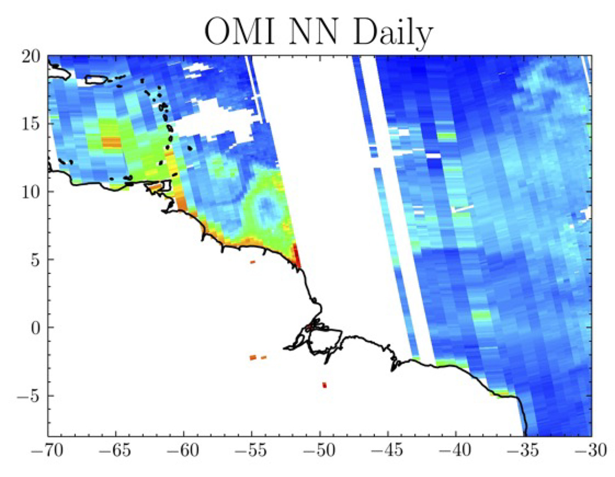
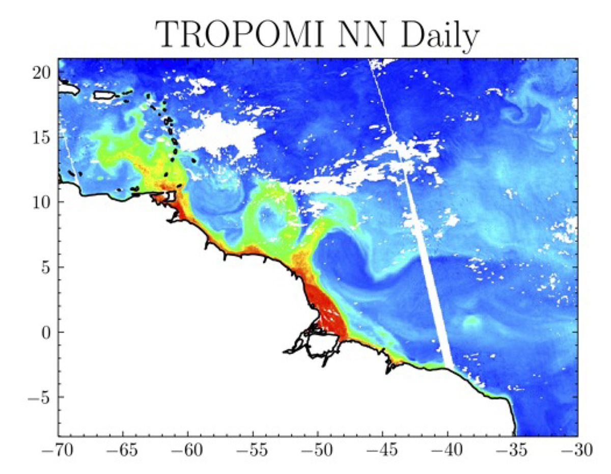
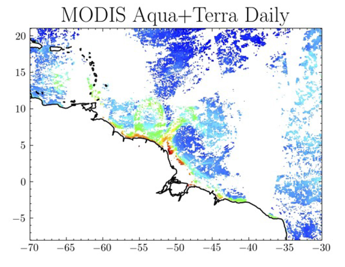
Daily chlorophyll off the northern coast of Brazil on October 15, 2020 from OMI NN approach (left), TROPOMI NN approach (middle), and MODIS Aqua and Terra combined chlorophyll retrieval (right).
Technical Description of Figure(s):
Daily Chlorophyll concentration off the northern coast of Brazil for October 15, 2020 from OMI on the left, TROPOMI in the middle, and a composite of MODIS Aqua and MODIS Terra on the right. The OMI and TROPOMI images show much improved spatial coverage compared to that from MODIS.
Scientific significance, societal relevance, and relationships to future missions:
Satellite based retrievals of ocean properties are important for further our understanding of the ocean ecosystem. Many of the current algorithms for ocean color retrievals are limited in less-than-ideal retrieval conditions including clouds, aerosols, and sun glint. We’ve developed a novel technique to “fill the gaps” left by clouds, aerosols and sunglint in current ocean color retrievals using hyperspectral instruments, substantially improving spatial coverage compared to instruments such as MODIS/SeaWIFs. In this technique, a principal component analysis is used to separate out the different spectral features in the hyperspectral measurements. Given these different spectral features, machine learning algorithms are then employed to learn the relationships between these spectral features and retrieved quantities such as remote sensing reflectance and chlorophyll concentration. In this work, we apply the approach to the hyperspectral Ozone Mapping Instrument (OMI) which has been in flight for more than 17-years and could help to fill the gaps in historical ocean color datasets such as MODIS and SeaWIFs. Additionally, we apply the technique to the Tropospheric Monitoring Instrument (TROPOMI) which has a high spatial resolution for a hyperspectral instrument and could be used to provide “gap-filled” ocean color information operationally in coming years as well as a near-real time ocean color dataset.
In the future this novel technique could be applied to many future hyperspectral missions including the geostationary missions TEMPO and GEMS, possibly enhancing the diurnal coverage in ocean color information. Additionally, it will be applicable to the future ocean color missions including PACE OCI and GLIMR as they will take measurements at much higher spectral resolution than the heritage ocean color instruments such as MODIS and SeaWIFs.
Data Sources:
OMI (Ozone Monitoring Instrument), TROPOMI (Tropospheric Monitoring Instrument), Aqua MODIS (Moderate Resolution Imaging Spectroradiometer), and Terra MODIS
References:
Fasnacht, Z., Joiner, J., Haffner, D., Qin, W., Vasilkov, A., Castellanos, A., and Krotkov, N. Using Machine Learning for Timely Estimates of Ocean Color Information from Hyperspectral Satellite Measurements in the Presence of Clouds, Aerosols, and Sunglint. Accepted by Frontiers in Remote Sensing, 2022.
04.2022

